1 2
FooBag
FooBag Reader
6/24/17 9:33 p.m.

This coming weekend and a few days following, my girlfriend and I are going to be road tripping along the Oregon Trail.

First, a little back story. My girlfriend (SWMBO from here forth) has been extremely interested in pioneer times, thanks to the Little House on the Prairie books. In May, I attended a work training in Fort Collins, CO and took a bit of a detour on the way home. This allowed me to stop by Scotts Bluff National Monument and Chimney Rock in Nebraska. The pictures I took really peaked SWMBO interest and started a discussion of taking a trip along the trail to see the sights and sites. I decided to burn my last few unscheduled vacation days of the year around the 4th of July to allow us to cover a bunch of the trail.

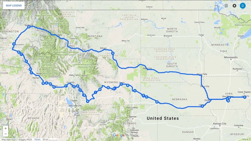
Here's the overview of our route. The total mileage will be somewhere around 3700 miles. With the exception of our first night in Lincoln, NE, we'll be tent camping at campgrounds along the trail. Our stagecoach will be SWMBO 2013 Buick Verano, so there likely won't be any GRM tales of hasty repairs along the road.

Here's the itinerary for our trip.
Day 1
Ash Hollow State Park
Chimney Rock Visitor Center
Scotts Bluff
Robidoux Pass
Fort Laramie
Guernsey Ruts

Day 2
Ayres Natural Bridge
Fort Caspar
Independence Rock
Devils Gate/Mormon Handcart
Ice Slough
South Pass
Big Sandy
Fort Bridger

Day 3
Fossil Butte (not actually on the trail, but we couldn't pass this up)
National Oregon/California Trail Center
Soda Springs (Hooper & Pyramid)
Lava Hot Springs
Massacre Rock
Shoshone Falls
Thousand Springs
Three Island Crossing

Day 4
Bruneau Dunes
Keeney Pass
Alkali Springs
Flagstaff Hill/Oregon Trail Interp Site
Blue Mountain Interp Site
Pendleton

Day 5, we start heading for home.
Spokane, WA - We're taking this slightly longer route back home, as SWMBO was born in Spokane, but moved to Iowa before she has memories. This route only adds about an hour to our travels.
Garryowen, MT

Day 6
Home

If anything goes wrong (unlikely), I have the very hard deadline of needing to be home by 11am on Thursday. I've got a flight to DC to catch at 1:30pm as I'm the event chair for the SCCA East Rallycross National Challenge.

If anyone has any suggestions of Oregon Trail sites or other interesting things that we should hit up on this route, I'm all ears. I've packed our days quite full, but sleep can always been skipped. Once we're on the road, I probably won't be posting updates, but I'll do a big update after we're back.

conesare2seconds
conesare2seconds Dork
6/24/17 10:10 p.m.

Huge trip with a hard deadline. What could go wrong? This is great.

BrokenYugo
BrokenYugo MegaDork
6/24/17 11:25 p.m.

Avoid questionable water sources, dysentery sucks.

Stefan
Stefan MegaDork
6/25/17 12:12 a.m.

The end of the Oregon Trail Museum in Oregon City would make for a good stop.

You could hit up the World of Speed Museum in Wilsonville on the way there or on the way back. They hold a Cars and Coffee event there every Saturday morning and the Museum is pretty cool to see.

FooBag
FooBag Reader
6/27/17 11:27 a.m.

In reply to Stefan:

Thanks for the suggestions! I don't think we're going to make it that far into Oregon, but you never know.

NOHOME
NOHOME UltimaDork
6/28/17 5:34 a.m.

Going to suggest a nicer drive through SD. Grab hwy 14 out of rapid and you will see a great slice of the state and cut a bit of distance out of the cross-state drive. The drive along interstate 90 and 29 is pretty sterile.

FooBag
FooBag Reader
6/28/17 8:57 a.m.

In reply to NOHOME:

Thanks! I will keep that in mind. Since that will be the last day of our travel, the extra hour of travel time may lead domestic homicide. We'll see how the attitude is when we make it to Rapid City.

T.J.
T.J. MegaDork
6/28/17 9:29 a.m.

In reply to NOHOME:

That route takes the Corn Palace out of the route....

T.J.
T.J. MegaDork
6/28/17 9:35 a.m.

If you are not in a hurry to get from Kennewick to Spokane,consider taking Hwy 12 over to Lewiston/Clarkston, where you can make a quick detour to see Hell's Canyon, then head up the old Lewiston Grade and head to Spokane via Hwy 195. This would add about 2.5 hours, but may be worth seeing while your've out there. Here is a pic of the road looking down from the top.

Jim Pettengill
Jim Pettengill HalfDork
6/28/17 1:10 p.m.

The restored "ghost town" at South Pass is very good, budget a little time to see it. Not just tarted up for the tourists, it's actually restored, with good interpretive info.

FooBag
FooBag Reader
6/28/17 11:04 p.m.

In reply to T.J.:

Hell's Canyon looks really cool. I suspect I'll be overruled on any detour that day though, as SWMBO is very keen in exploring Spokane. Knowing how her mind works, I can pretty much bet that we'll be back to the area within the next year or so. I'll plan on hitting up your suggestions then.

In reply to Jim Pettengill:

Thanks for the heads up! I hadn't seen mention of the restored town in my planning, so I'm glad you let us know.

FooBag
FooBag Reader
7/6/17 8:30 a.m.

We made it back without issue! Final mileage traveled was 3,977 in 7 days. I'm now scrambling to do laundry and pack to head to the East Challenge, so I'll do a long update with pictures early next week.

FooBag
FooBag Reader
7/17/17 9:48 a.m.

Okay, I finally have the time to fill in the details of this trip!

We started off on Thursday afternoon after I ducked out of work a bit early. Packing all our stuff into the Verano was a bit challenging as the hinges for the trunk have large arms that take up an unfortunate amount of room when closed. I don't know why GM had to go backward to this annoying design, as my Cobalt's trunk hinges didn't do this.

In any case, we cruised out, dropping our pooch off with SWMBO'd dad, then heading onto Lincoln, NE for our first night. This is a simple drive across I-80, so there's nothing interesting of note. Day 1 distance covered: ~330 miles.

The following morning, we were on the road by 7 am and heading for our first stop along the Oregon Trail, Ash Hollow State Park in Lewellen, NE. Given the width of Nebraska, this was a long 5 hour drive. We arrived at Ash Hollow about 11 am (hello, mountain time!) and checked out Windlass Hill, a very steep hill that the pioneers had to negotiate. There's still a pretty good swale in the ground, where the wheels from the wagons cut into the ground. It was a bit hard to photograph, especially with the tree growing up in the center of the swale.

We then checked out the visitor center/museum at the park. They had some decent exhibits, but it was obvious the museum hadn't been updated since the mid 90's. I'd still recommend checking it out if you're ever in the area and want to learn about the trail.

Next up was Chimney Rock, a spire of rock that was a waypoint on the trail. There's another visitor center/museum at Chimeny Rock, but you can't officially get very close. The best view can be had by driving just a bit south of the visitor center and then taking a right on the gravel road. This will get you much closer. Supposedly, there's a hiking trail on private property that will get you right out to the rock. We were pressed for time, so we didn't attempt to locate this.

Since the internet has done a fine job of ruining us all, I suspect it won't be just me who found the Native American name for Chimney Rock quite amusing.

There was this awesome expedition rig in the parking lot of the Chimney Rock museum. Unfortunately, I didn't get a chance to talk to the guy as they were backing out as I snapped this picture. It did have Mercedes badging on it though.

Next up was Scotts Bluff, another way point for the pioneers. This has been turned a national park and they even carved a road up and through the bluff so you can drive to the top (sorry, my photos of this didn't turn out). They have a small museum and outdoor wagon exhibits. My pictures don't really do it justice, but I'd definitely recommend stopping in if you're in the area.

We decided to skip Robidoux Pass based on comments from park staff and instead headed straight to Fort Laramie. If you like historical exhibits, this place is wonderful. They've got 15 or so restored buildings with exhibits in each. They also do a field artillery demonstration with period correct field pieces. Be forewarned, the fort complex is spread out over many acres, so if you want to see everything, you'll need to allot 3-4 hours. We did a more rushed tour of the site and then moved onward.

Our final stops of the day were the Guernsey Ruts and Register Cliff. At Guernsey, the wagons were negotiating steep limestone hills, so the wheels cut very deep ruts into the stone. Some of these are literally 3+' deep. It's very striking to know these ruts are over 150 years old and still plain as day.

Register Cliff is a limestone cliff about a half mile away from the ruts where many pioneers carved their names. Sadly over the years, many shiny happy people have destroyed these to carve their own names into the rock. There's still a portion with some visible carvings from the 1800's that is protected by a fence. Here's a picture of one of the better ones I was able to photograph.

We ended the day camping at the Trail Ruts golf course and campground, within site of the ruts and cliff. This was a nice quiet campground with decent bathroom facilities. If you're ever thinking of staying here, please note that their posted shower rate of $4 only applies if you're not camping at the campground. Day 2 distance covered: ~470 miles.

FooBag
FooBag Reader
7/17/17 10:58 a.m.

The next morning we were awakened about 5:30am thanks to sun being so bright that sleeping in was impossible. Keep this in mind if you plan on tent camping on a trip like this; you won't be sleeping in. On the plus side this means we had our campsite broken down, car packed, morning consitutional taken care of, and on the road before 7 am.

Our first stop of the morning was Ayres Natural Bridge. While technically not on the Oregon Trail, it was quite close and certainly a unique formation worth checking out. Over the years, the stream had worn a hole through the rock bluff, leading to this natural bridge. It's situated in a nice little park that I don't think gets many visitors; we were literally the only people there. The park caretaker came out to talk to us, wanting to know how we heard of the park, after he noted that we had Iowa license plates.

Next up was supposed to be Fort Caspar, but when we got to Casper, WY, we started seeing signs for a Trails Historic Center/Museum that we had somehow missed in our trip planning. We opted to hit this facility instead. It's a very modern museum, with great displays for all ages. We tried to keep our visit brief, since we had a lot of distance to still cover, but still spent over an hour.

We then headed for Independence Rock, with a brief pit stop at Red Buttes Crossing, to eat a picnic lunch on the banks of the North Platte River. Apparently this is a popular point to go tubing on the river, so there was a lot of eye candy to enjoy. Amusingly, Independence Rock is accessed from a rest stop on Hwy 220. This giant granite dome (picture doesn't do it justice) was another way point on the trail. The pioneers' goal was to reach this rock by the 4th of July, as this greatly increased the odds you'd make it through the mountains before late fall/early winter snow storms hit. Again, many pioneers left their mark on the rock, either by chiseling into it or painting their names with a mixture of axle grease. Surprisingly, these painted names have held up for 150 years. We didn't find many names, mainly as we didn't have time to around or climb up on the rock.

We headed ever westward, with the Devil's Gate as our next stop. This is an interesting formation where Rush Creek wore a gap through a ridge as it was being heaved up by plate tectonics.

We continued following the trail, with the next way point being Split Rock, a formation in the hills that looks like a gun sight. Unfortunately, we passed the last turnout to get a good picture of this formation, so there's not picture to share.

Next up was the Ice Slough, a marsh area were ice would form under the surface in the winter and then be protected from melting in the summer by a thick layer of peat. The pioneers could dig down and find ice in July, despite temperatures near 100. Thanks to ranching and climate changes, the ice no longer forms, but you can still see a green swale in the ground.

We continued on through Wyoming, turning off onto Hwy 28. You gain quite a bit of elevation in the first few miles of this highway. I'd recommend stopping at the overlook, as the view of the valley with red rock bluffs was quite nice. You'll also be needing a break from being in the car at this point.

Hwy 28 lead us to our next stop at South Pass City, thanks to Jim Pettengill's recommendation. This site turned out to be SWMBO favorite stop! They have a dozen restored buildings from the gold rush era. There were very high quality displays, from stores and saloons to mines. Interestingly, here we learned about Wyoming having been at the forefront of Women's Suffrage, being the first state to allow women to vote. It's definitely not what you'd expect from a ranching and mining oriented (at the time) state. We snagged a lot of pictures of the displays, which I won't bore you with, but I did find this "dump" wagon interesting.

Having spent a ton of time at South Pass City, we now were behind schedule and needed to make it 150 miles to Fort Bridger, WY for our next campsite. Thankfully, Hwy 28 is very sparsely traveled, so I may have covered quite a few miles at 90+ mph. This allowed us to arrive with about 45 minutes of daylight left to set up camp and make dinner. We were unfortunately too late to check out the Fort Bridger historical site. I will highly recommend Fort Bridger RV Camp as a site to stay. The rates were cheap, the bathrooms very nice and spotless, and the owners very friendly.

Day 3 distance covered: ~435 miles

FooBag
FooBag Reader
7/17/17 3:58 p.m.

Once again we awoke before 6 am thanks to the sun and were on the road by roughly 7am. We were unable to check out the Fort Bridger Historical site again, as it didn't open until 9am. We hit the road, heading instead to the Fossil Butte National Monument. The fossil specimens on display at the visitor center were amazing, with interesting oddities such as fish that had died after trying to swallow another fish (skeletons intertwined) and a turtle with obvious puncture holes in its shell from an alligator or crocodile. I forgot to take any pictures while I was there. There's a number of hiking trails at the site, one of which leads up the butte to a site where the original property lived, making a living by mining the fossils and selling them. We opted to take a trail that just ran along the top of the ridge near the butte, due to time constraints. This worked out well as we came across a herd of pronghorn with babies. They weren't too scared of us and slowly sauntered away.

We opted to skip the National Oregon/California Trail Center in Montpelier, ID as all the museums were starting to get repetitious. We moved on to Soda Springs, ID a site where there were numerous natural springs that the pioneers took advantage of. One of these, Hooper Springs, actually has naturally occurring carbonated water. You could see the bubbles of carbonation coming out of the ground. We sampled the soda water; it essentially tasted like crappy well water (lots of minerals) with carbonation. https://www.youtube.com/embed/hggp3yTJL8U?ecver=1

Apparently there was quite the industry in Soda Springs in the late 1800 and early 1900's thanks to the soda water. It was bottled/barreled/shipped in tanker cars back east for use in beverages (mainly alcoholic). According to the information on site, the Prohibition killed this industry.

We then headed on to Pyramid Spring, where business men of the late 1800's tried to tap into the hot water that was coming out of the ground. They ended up hitting a high pressure pocket of water, creating a geyser. They capped it off and turned it into a tourist attraction with a valve that releases the pressure on the hour, every hour. The minerals in the water have lead to quite the build up of orange material.

We started heading west again, with our next destination being Shoshone Falls. This is a set of waterfalls on the Snake River that is referred to as the "Niagara of the West". This place was absolutely packed and we had to drive around the parking lot for 15 minutes before snagging a spot. However, it was well worth it. The falls were very impressive. We came at a good time of the year, because at certain times, there are no falls, due to the extreme water use for irrigation upstream. Due to some unique geology in the area, most of the water used for irrigation ends up back in the river downstream of the falls, so the river continues.

By this point in the day, temperatures were getting pretty extreme in southern Idaho. From about 1pm until 7pm, it was over 100 deg. The temperature really wore on us and made us much less interested in exploring the sites and more interested in staying the AC of the car. We did stop at the Thousand Springs area, where huge springs pour out of the bluff and into the Snake River. This didn't photograph well, via my phone, but the white streaks is water pouring out of the bluff.

We then moved on to the Malad Gorge, a narrow canyon cut into the ground by the Malad River on its way to the Snake River. I-84 goes right across this gorge, but you'd hardly notice from the interstate. You can see the I beam of the bridge in the top portion of this picture.

Finally, we moved on to Three Island Crossing State Park, the place where the pioneers crossed the Snake River for the last time. This was our campground for the night as well. Unfortunately, I don't have much of anything good to say about this park. The rates to camp as an out of state person were horrible. This was our most expensive stay and the worst site and facility. The bathrooms did not have soap or hand sanitizer dispensers. I don't mean they were empty or ripped off the wall; there weren't any there, period. While I'm not a germaphobe by any means, I certainly like to wash my hands after taking a deuce. The shower was right next to the toilets, separated by only a standard metal stall divider. Nothing quite like taking a shower with a 3/4" piece of metal between you and someone with a bad case of the beer E36 M3s.

Day 4 distance covered: ~400

llysgennad
llysgennad New Reader
2/27/19 10:22 a.m.

And?...

llysgennad
llysgennad Reader
2/27/19 10:38 a.m.

Genuinely curious what your thoughts are on this trip. I live near the start of the Trail, and have been to a few of the places (Scottsbluff and Wyoming) and I want to do the entire trail like you did someday.

Thanks for this travellog!

FooBag
FooBag Reader
2/28/19 3:15 p.m.
llysgennad said:

And?...

Ha, I guess I forgot to finish this off!  I'll try to put together the rest over the next day or two.

Thoughts on the trip:  It was a blast!  We did get a bit worn out of Oregon trail stuff by day 5 and ended up revising our plans to skip the last of i for the last few days.  By that point, all the museums and road side stops felt like they were covering the exact same material.

Of all the things we stopped at, the favorites were the Guernsey Ruts & Register Cliff, Fort Laramie, Ayres Natural Bridge, South Pass City, & Shoshone Falls.  The best museum we hit was Trails Historic Center/Museum in Casper, WY.  I personally enjoyed the Fossil Butte National Monument as I've always loved fossils, but the fiance (now wife!) was much less enthused.

I would definitely recommend a trip like this if you like pioneer history and want to see some interesting scenery along the way.

FooBag
FooBag Reader
2/28/19 4:18 p.m.

Okay, so 1.5 years later, I guess I'll finish up this trip log!

So as alluded to at the end of my last post, the campground at Three Island Crossing State Park in Idaho sucked.  We got a poor night of rest, thanks to the temps being quite warm (95 deg F at 10 pm at night) and got on the road very early in the morning.  We headed first to Brunea Dunes State Park, which has the tallest single sand dune (470') in North America.  On the way to this park, we passed miles of wheat fields that appeared to be ready for harvest.  Having never seen wheat fields like this, SWMBO requested a stop so she could get pictures.  We parked on a driveway/field access and then had some unexpected excitement as an apparent drunk driver just barely missed sideswiping our car on his way into the ditch.  He drove out of the ditch and continued on.  He must have been at a hell of a party, as this occurred at about 6:45am.

Anyway, the Bruneau Dunes were pretty cool.  The sand is a chocolate brown color and was pretty tightly packed so we climbed to the top of the dune.  Amusing there were people there sledding down the dune and other fishing in the lake next to it. I did get stung by a very persistent bee that harrassed me all the way from the parking lot to the top of the dune before it finally stung me. 

We then hopped on the road towards the Keeney Pass in Oregon.  While on the road, we decided that we had pretty much had enough Oregon Trail related tourism and decided to modify our travel plans.  We were going skip straight to the National Historic Oregon Trail Interpretive Center and Flagstaff Hill in Baker City, OR as our final Oregon Trail stop and then head straight to Spokane, WA.

The National Historic Oregon Trail Interpretive Center was the second best museum we hit on the trip and I would definitely recommend it.  It sits on a decently tall hill that overlooks Baker City.  It was still possible to see the main wagon path after all these years.  The trail wasn't super deep like at Guernsey, WY, but it was definitely evident.

We then settled in for a long haul to Spokane (nearly 5 hours).  We arrived in the late afternoon and immediately headed to the neighborhood where SWMBO parents lived when she was born.  We then headed to downtown Spokane where the Spokane River flows right through the center of town.  There's a ton of nice parks along the river and I would highly recommend checking out the area.

We were tired of the camping meals we had been cooking at this point, so we decided to hit Longhorn Barbecue in Spokane Valley, WA for dinner.  The food was great!  Interestingly, later that night when we told SWMBO father where we had eaten, he laughed and informed us it was a place SWMBO parents frequented when they lived there.

We finished up the day camping at the KOA in Spokane Valley.  This was a nice campground with nice bathrooms and amenities.  It is fairly close to some busy railroad tracks, which lead to some disrupted sleep in our tent.

Day 5 distance covered: ~540 miles

nutherjrfan
nutherjrfan UltraDork
2/28/19 6:03 p.m.

Man you must have really annoyed that bee. laugh

Very inspirational trip. smiley

Pete Gossett
Pete Gossett MegaDork
3/1/19 5:24 a.m.

In reply to nutherjrfan :

Thankfully he didn’t die of dysentery. 

llysgennad
llysgennad Reader
3/1/19 10:37 a.m.

Thanks for updating this! It is an inspiring trip, and I hope to make it someday. I grew up next to the Santa Fe trail, and I do enjoy history and excursion trips like this.

If you haven't read it, this is a hilarious book about following the Oregon Trail in a wagon pulled by mules. The running battle with RV's and motorhomes is great.

Congratulations on the marriage, and sorry about the bee. I swallowed one once, that really sucked.

FooBag
FooBag Reader
3/1/19 11:29 a.m.
nutherjrfan said:

Man you must have really annoyed that bee. laugh

Very inspirational trip. smiley

I honestly have no idea what in the world I did to anger it so much. I of course was doing the typical running, ducking, dodging, and swatting at it, which was highly amusing to my better half.

One of our major takeaways from this trip is that we're all a bunch of pansies compared to the pioneers. The things they endured are just incredible.

FooBag
FooBag Reader
3/1/19 11:31 a.m.
llysgennad said:

Thanks for updating this! It is an inspiring trip, and I hope to make it someday. I grew up next to the Santa Fe trail, and I do enjoy history and excursion trips like this.

If you haven't read it, this is a hilarious book about following the Oregon Trail in a wagon pulled by mules. The running battle with RV's and motorhomes is great.

Congratulations on the marriage, and sorry about the bee. I swallowed one once, that really sucked.

You're welcoming and thank you for the congrats. That book is on my "to read" list. My wife was reading me bits from it while we were driving across the country. 

FooBag
FooBag Reader
3/1/19 12:18 p.m.

Day 6 dawned and we were up early yet again. Are you sensing  a theme here? laugh It's pretty much impossible to sleep in while in a tent. We contemplated driving up Mt Spokane, prior to leaving the area, but decided against it as it was going to be a three hour round trip without advancing us towards our next campground, 600 miles away. Not wanting to leave Spokane without at least a bit of nature hiking, we went to the Antoine Peak Conservation area just north of the KOA and hiked for about an hour. I have no pictures to share, as there really wasn't anything outstanding here, but it was nice to get outdoors.

We then hopped back on I90 as stated heading east. I90 runs through Coeur d'Alene, a very scenic area of Idaho and then into the Bitteroots mountains. It runs along a narrow valley for most of the stretch, so you're completely surrounded by mountains. We took a pit stop in Kellogg, ID to get some breakfast. We chose poorly and ended up burning almost 90 minutes due to incredibly slow service at the restaurant.

Getting back on the road, I put the hammer down, as it was now 10am and we had 540 miles to go. This would put our arrival into our campground somewhere around 6 pm, thanks to a time zone change and pit stops along the way. This would allow us time to check out the Little Big Horn battlefield, which was just down the road.

Again, I'm sorry I don't have pictures to share, but we didn't have much opportunity to stop. I will say that the drive across Montana, while long, has no shortage of mountainous scenery to look at. 

At about 5:40 pm, a voicemail came through on my phone, that had been left about 5pm, from our planned campground. They stated they were closing up the gates at 5:30 pm that evening, due to it being the Fourth of July. If we didn't make it there by that time, we wouldn't be able to camp there. I immediately called them back, but there was no answer. We continued on in the hopes of there still being someone around when we arrived, but the place was deserted when we got there. This set off a mad scrambled of googling to try to figure out a new campground for the night.

We ended up snagging a spot at the Devils Tower KOA, but it was over 200 miles further east from where we were. Thankfully, most the route was very lightly used highways, so I was able to really put the hammer down and shave some time off on the way.

This route took us through the Northern Cheyenne Indian Reservation, which was an eye opening experience. The extreme  poverty was very evident, even from the highway. The only thing not run down was a casino. It was truly appalling evidence of the terrible way the government treated the Native Americans during the westward expansion and how that situation has never been rectified. 

As we continued on, we passed through miles of fields that had been heavily colonized by prairie dogs. My better half is very much an animal lover and begged me to slow down so that I didn't run one of the furry critters over. I did slow some, but not much knowing we were quite pressed for time. All was good, until one smart a$$ decided to sit exactly on the center yellow line, perfectly camouflaging him, until I was a few yards away. I cursed and tried to avoid him, but he darted perfectly into the path of our wheels and began a new career as roadkill. Hearing my curse, my girlfriend looked up just in time to witness this all. Much upset ensued and I got a lot of grief for being a prairie dog killer. frown She did forgive me eventually.

We arrived at the KOA at about 9:15, with just a bit of twilight left in the sky. Setting the tent up using the car headlights was a chore, but I made it work. Unbeknownst to us, the KOA puts on a large fireworks display every Fourth so we were able to enjoy it. The flashes of the fireworks lit up Devils Tower, providing a very unique backdrop for the show. I would definitely recommend catching the show if you happen to be near Devils Tower on the Fourth. It was the perfect end to a very long day of driving.

One amusing occurrence from this long day was we learned that there is apparently a limit on how many times you can use a credit card to pay at the pump during a day. First, here's a bit of backstory to set the stage. On the second day of the trip, we nearly ran out of gas, thanks to the sparsely populated areas and infrequent gas stations. This made us institute a rule that if we saw a gas station and we were at less than a half of a tank, we stopped to fill up. While the girlfriend's Verano is fairly fuel efficient (28-32 mpg), you end up stopping a lot with the above rule when you travel over 800 miles in a day. We were nearly to Devils Tower and stopped for gas. The pump informed me my card was declined, which had me going WTF?, knowing there was thousands of head room on the card. I went inside to ask about it and the clerk could see it has been declined for "too frequent use." Running it from the register allowed it to go through workout issue though.

Day 6 distance traveled: 830 miles

1 2

You'll need to log in to post.

Our Preferred Partners
SaZ4Y4byDaoRyoBOXNLAOfF3lg6ouJuJVTnvXBZdRcFMON3BA3ZhDhLF91rK2L40