Ok, so it was more like two days but still.
The plan was to take my father's boat from Edisto Island, SC to Savannah, Ga traveling the Intracoastal Waterway. A distance of about 70 nautical miles, about 80 regular miles.
The vehicle. This is a 2002 42' Symbol aft cabin trawler. It is powered by a pair of 330 hp Cummins 5.9l turbo diesels. At WOT it will run about 20 knots, 23 mph. Not too bad for a 20K pound boat. Unfortunately, at that speed is burns an enormous amount of fuel. Its most efficient speed is about 8 knots, where it gets about 2.5 mpg.

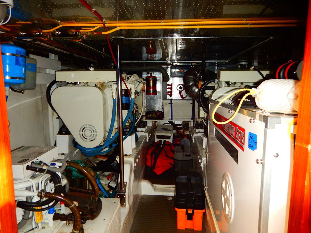
Because I know you want to see them, the engine room. Not quite clean enough to eat off of, but they are well taken care of. The white box on the right is the generator. It's powered by a 3 cyl diesel and puts out around 8kw.

Saturday morning we left the dock about 8am and headed out. It drizzled the entire time we were loading but quit about the time the engines started and stayed mostly dry the rest of the day. Temps were in the 60s and it was overcast with no wind. Actually perfect weather for a boat cruise.

The family farm is on Store Creek, about 10 miles from the ICW. The tide was dead low, which made for some slow stretches with less than a foot of water under the keel. We made it out of the creek without hitting bottom. That's always a good thing. It doesn't take much to stick 20k pounds and end up waiting for the tide to float you off. Store Creek leads into the South Edisto River about a mile from the Atlantic Ocean, where we ran into a fog bank. Visibility dropped to around 400 yards.

That makes it a little hard to pick out the next channel marker. Dad has a chart plotter and radar on the boat for picking out markers, boats and other obstructions when the fog closes in.
This is a poor overview of the dash. The big screen in the middle is the chart plotter, depth sounder, and radar. They can be run as a split screen so the radar and chart plotter are visible at the same time. The small screen on the left is also a chart plotter and depth sounder. It is there for redundancy incase the main system dies in the middle of nowhere. Below that is a VHF radio for talking to other boats, the Coast Guard, and marinas. There is another radio at the lower helm. The small LCD to the left of the main screen is the autopilot. To the left of that is a radio. Below the radio is the engine synchronizer. The two black circles are the controls for the bow thruster. With the amount of windage a large boat has, they are handy for pushing the boat off of on into docks. It saves wear and tear on the paint. The rest of the gauges at the bottom of the picture are engine controls and gauges.

You might notice the white block with the red and green wire nuts on it. That's a reminder for which side of the channer markers you need to be on. Red is to the right when returning from sea or heading south. If we had been headed north, we would have turned the block around to put the green on the right.
Post break so I don't lose the entire thing. Back in a few.
I used to work for a yacht maintenance company and spent a lot of time on similar rigs. That's a seriously nice boat right there.
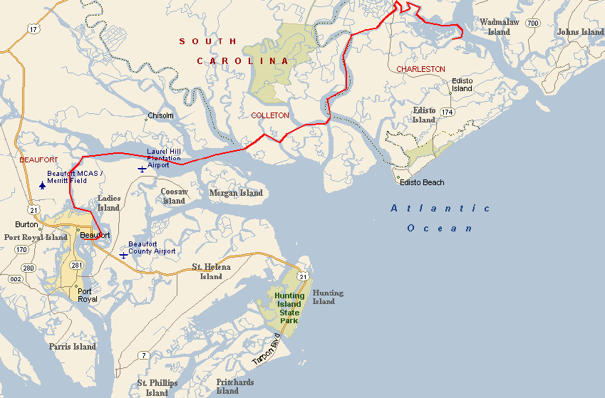
After an hour or so, most of the fog had burned off and we pushed the throttle up to 1400 rpm. That gave us right at 8 knots We met up with the waterway at Fenwick Cut and turned south. Our start point is about where the E is on Edisto Island. Fenwick Cut is the short straight between the words Colleton and Edisto. About 3 hours later we were cruising into Beaufort where we stopped for fuel.

Beaufort is one of those old historic towns that are scattered all up and down the Atlantic Coast. It was chartered in 1711 and is the second oldest city in South Carolina. It's a pretty area of old houses and ancient oaks. From the ICW it looks like a marina with a few building behind it.

We stopped at the city marina and took on 300 gallons of diesel. Dad hadn't bought fuel since he was in Virginia last August.
From there it was a cruise till we stopped behind Daufuskie Island for the night.
A flock of white pelicans. We don't see them often around here. Not a good shot, but I left my good camera at home.

It stayed overcast the entire trip and with the humidity around 100% the windshield never did dry out completely.

The water did stay surprisingly calm. Even the stretches with little to no protection from the ocean only had gentle rollers.


Bald Eagle on top of a dead tree. I really wish I had brought my good camera.

I still managed some decent shots with the point and shoot and my cell phone.

The United States Marines apparently don't want visitors at their air base. I noticed Parris Island didn't have any of these signs posted. They probably used the uninvited as training.

About 4pm, we stopped for the night. Running after dark is a good way to get stuck on a bank. Rather than trying to find a marina to tie up in, we just picked a creek off the ICW and dropped anchor. Dinner was steak, potatoes, squash and a salad. Food always seems to taste better when you aren't at home. I fixed lunch, so Dad had dinner duty. The galley isn't huge, but it's not exactly cooking over an open fire either.

Then it was time to enjoy the peace and quiet of the coast, and a beautiful sunset.


We were both in bed by 8:30.
The next morning we woke up to a down pour. It rained steady from 6 am till 8 am. We got breakfast together and by the time we were ready to roll, the rain had settled into a drizzle that lasted another hour. It was another gray morning. We had made much better time than expected the day before and were only about 18 miles from our destination.

The markers up and down the waterway are pretty important. Sometimes you disregard them at your own risk. At a guess, this boat ran a ground the previous evening and spent a rather long and uncomfortable night stuck on the bank. BoatUS was there to try and get them off. I'm betting they had to wait until the tide came in. Notice the red buoy by the BoatUS boat. If you remember, he should have been to the left of that.

The crossing at the Savannah River was completely fogged in. Dad made a security call on the radio to make sure there weren't any ships coming and we eased across using the radar.


From there it was only a few more miles to the marina where the boat will be spending the rest of the winter.


Next spring the boat will be headed farther south and across to the Bahamas. I'll have to see if I can make that trip as well.
In reply to Woody :
Woody he takes very good care of it. He's an engineer and just a little anal about upkeep. Not a bad thing when it comes to a boat. Deferred maintenance has sent more than a few boats to the bottom. It just came out of the yard from a bottom paint job, a check of all the through hulls, and lube and exercise of the sea cocks. They usually spend 4-8 months a year on the boat, but this might be the last year. He's turning 80 this year and it's getting to be a bit much to handle.
In reply to Toyman01 :
Never having spent any time on water, I find this all completely fascinating!
Awesome. If you ever need crew let me know. I'm a hell of a cook and pretty handy around a boat.
Actually, we have friends with a house right off the Creighton Narrows tide marker on the ICW about halfway between Savannah and Darien. If you end up running that next leg south next year it would be cool to raft up for lunch or something.
Also the channel marker reminder is genius. Never seen that before.
In reply to 84FSP :
Sometime around 1964 or 65, my mother did the ICW with my grandfather from CT to Savannah in their boat. She remembers the fuel costs being substantial even back then. The boat was a good bit smaller (30'ish feet?), but with less efficient twin Chrysler V8's. After getting to Savannah, he had it trucked up to Lake Lanier near Atlanta which is where I remember it from my early childhood.
Definitely want a boat some day... once I can get past the internal 'hole-in-the-water" stigma... Living near water (Delaware river) doesn't help.
Toyman - Make sure you bring the "good" camera for the Bahamas trip. ![]()
In reply to Toyman01 :
Highly suggest harbour island, although it’s a narrow spine there at the end.
SVreX said:I’m in Beaufort- you drove right past me!
We should see more fishing posts from you, then! I'd like to retire down that way.
You'll need to log in to post.